Windsor, Nova Scotia
This town is located at the fork of the Avon and St. Croix rivers in the central section of Nova Scotia.
The Indian name was Pisiquid (Pigiquid, Pesaquid), 'the place where the tidal flow forks'. On December 24, 1764, the township was erected under the name of Windsor, after Windsor, England, the chief residence of royalty for many centuries.
There is some evidence of French Acadian settlement in this area as early as 1684 when Catherine Landry was born at 'Pigiquit'. In 1703 Heritiers Latour was granted a concession of land in this area. Lands within the township were granted to Brigadier General Richard Philipps, Lietenant-Governor Lawrence Armstrong and others in 1736 and had to be escheated before the new Windsor township could be set up in 1764. By 1714 there was an Acadian population of 337 in the area. Some of the villages in the vicinity were called: Trahan, LeBraux, Landryville, Forret, Babin, Rivet, and St. Croix. In July, 1750 Fort Edward was built for the protection and the more effective control of the area. Many of the first inhabitants were Presbyterians from the North of Ireland; tenants living on land owned by absentee landlords living in Halifax. In 1781 the townships of Falmouth, Windsor, and Newport, and contiguous lands were erected into the County of Hants.
One of the earliest English schools in the town was begun January 1, 1767 with Samuel Watts as schoolmaster. In 1771 the chapel-school-community hall was built. The Academy was opened November 1, 1788, with Archibald Paine Inglis as schoolmaster. A new school was completed about 1849. Kings College was founded by an act of the Provincial Assembly in 1789. The college building was opened in 1797. About 1818-1820 the collegiate school on the Kings College grounds was built. It burned down in 1871, but was rebuilt by 1877. The Convocation Hall was built 1861-63, and Hensley Memorial Chapel was built in 1876-77. In February, 1920 the orginal Kings College building burned down. The College moved to Halifax in 1923 and was situated in newly constructed buildings in October, 1930. The buildings at Windsor were eventually utilized as the residence of a school for boys. Construction on the new Kings College school began in July, 1931. A new town school was built in 1867. A school on Victoria Street was destroyed in the great fire of October, 1897. Edgehill school for girls was opened January 8, 1891. A new building for its use was begun May 8, 1891. A new town school was built near the Academy in 1942. Windsor Elementary School was opened September 18, 1951. The new Town and Municipal Regional school on Wentworth Road was opened October 15, 1960.
Stores, warehouses, garages, etc. comprise the main industrial potential of the town. In earlier days, fishing, shipping and shipbuilding were major industries. Tourism is an important seasonal industry. The first agricultural fair in Canada was held at Fort Edward Hill in 1765.
Adapted from:
Public Archives of Nova Scotia. ([1967] 1982). Place-Names and Places of Nova Scotia. Belleville: Mika Publishing Company.
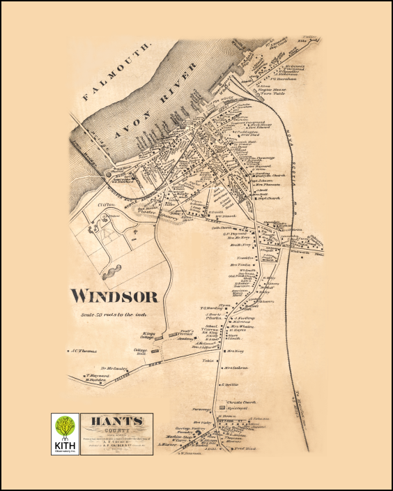 A. F. Church Map of Hants County
Windsor Town
Published in 1871 as a Lithograph
Conserved and Repaired in 2021
Digitized as a tif image
Mounted Plaque with black edges
Material is Medium-Density Fiberboard (MDF)
Printed @ 150 dpi
Plaque Size - 16 inches x 20 inches
Framed Print
Printed @ 150 dpi
Print Size - 16 inches x 20 inches
 KITH is working with heritage groups in Antigonish, Hants and Halifax counties to preserve and digitize the A. F. Church maps and match the map information with existing genealogical records. The goal is to improve our understanding of the history and social relations in nineteenth century Nova Scotia, and make this data publicly accessible.
